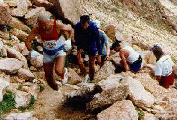
Photo1: Still more than two miles to the summit
Photo1: Still more than two miles to the summit
Pikes Peak is located near Colorado Springs and has an elevation of 14110 feet. Already, 107 years ago, in 1891, a railroad has been completed that goes up the mountain from Manitou Springs (6300 feet): it goes up more than 7000 feet in only 7.9 miles following a quite steep route (however, there are steeper routes in Switzerland...). The railroad was major tourist attraction in the beginning of the new century (and still is today). The Pikes Peak Ascent Race is run on the Barr trail, a hiking trail that goes up the mountain in about 12 miles. Finally, an auto road goes up Pikes Peak following a completely different route on the back of the mountain covering a distance of more than 20 miles --- it takes you forever (60 to 75 minutes) to go down the mountain: elite runners (it takes them about 75 to 80 minutes) have a good chance to outrun cars that go down the mountain, especially in Summer when there is a lot of traffic.
The Pikes Peak Ascent Race starts in downtown Manitou Springs at an elevation of 6295 feet and climbs up the Barr Trail and reaches the summit in 13.32 miles. The first 1.3M of the course are run on pavement, the remaining 12M are run mostly run on dirt, occasionally rock and gravel . After hitting the Barr trail, the course is quite steep gaining about 3000 feet going up Mount Manitou in about 4 miles; however, the trail is in very good shape and provides very good footing, and if you are able to run on more than 15% incline this is the chance to prove yourself (however, middle of the field runners should better walk this part of the course preserving energy for the "flat" middle part of the course and the tough last 3M of the course). Strangely, enough the next section of the course (miles 4.8 to 8.5) is quite flat going through a beautiful forest, and going even sometimes downhill. If you planned walk most of the race, this is the section of the course you should run. The next section of the course goes up to the A-frame (located at mile 10.2 of the race) is not too steep but the footing is not too good and there are a lot of small rocks (I found that even at the top of the mountain the footing is much better), and it is not too easy to run this section of the course. Shortly, after passing the A-frame you hit the tree line, and from now on it will be windy, significantly colder, and there will be much more rocks.
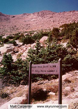
Photo2: Short after tree line ---
seing the last 3 miles of the course
Now, after you reached the tree line at about 11000 feet, you will be entering into another dimension: if you will look up to the summit of the mountain you will ask yourself: how will I ever get up there --- the remaining 3 miles is quite steep (almost 3000 feet elevation gain). However, the good news is that the trail will get you up there smoothly: however, if you ever get of the trail, you will have a very hard time going up the mountain. Another interesting thing is if you look up the mountain (and you are middle of the field as I was) you will be able to see the trail very well by just looking for the runners in front of you --- it is somewhat inspiring to see the caravan of hundreds of runners in the rocks (all leading you to the right path to the summit) that all have one goal in mind: getting up this mountain. The second challenge, especially most of us flatlanders will face the lack of oxygen. It makes your brain dizzy and even the simplest things seem to take for ever (for example, it took me almost 2 minutes to put on my jacket at 11500 feet): your brain is still working but only in slow motion. As a advice, avoid every activity that wastes unnecessary energy here! It is almost impossible to drop out of the race now (I, myself felt like dropping out at mile 12, but this thought did not even enter my mind: no matter how bad you feel there is no way of turning back, unless you want to walk more than 10M down or want to be taken up/down on a stretcher). You have to get up this mountain, and if it takes you much longer than originally planned this is still better than going down the whole way. If you run this part of the course this is impressive, if you speed walk the remaining 3 miles without taking any break this is impressive, if you sit down for 5 minutes at the next available rock and make it up the mountain like this in a couple of hours this is impressive.
In the last three miles the course you face all kind of challenges: you will walk over gravel, there are quite large steps on rocks, and then there are portions of "perfect dirt". However, you will climb almost 3000 feet on the last three miles (close to 20% incline), and breaking 12:30 pace on the last mile would mean running faster than course record pace --- the male median time for the last mile is 27 minutes. Looking up the mountain at this stage of the race is also not the yellow of the egg: even with one mile to go the summit looks very far away, and you proceed so slowly that it is discouraging to see your diminishing progress in the high altitude. Things will only change when your get very close to summit when you suddenly hear the noises of the finish line and see spectators that walked down to see the race.
Unfortunately, I had an upset stomach in the morning of August 15, 1998 that made the race quite difficult for me (my goal was to break 4 hours, a not too ambitious goal, but quite realistic, considering my lack of training in July due to the July heat in Texas, minor injuries and other reasons). I still was able to pass the A-frame in 2:43:30, but I completely fell apart on the last 2M of the course, finishing in 4:26:43 placing 777th overall, 66th of 137 in my age group --- it took we 42 minutes to complete the last mile (16 minutes slower than planned) but I was in the twilight zone, sitting down on rocks a lot.
In general, I believe Barr trail is a beautiful, and fascinating trail, and some day I plan to stay at Barr Camp (at mile 7.6 on the course at about 10200 feet) for a couple of days hiking and trail running: it seems to be a very nice place and there are many other places you can reach from Barr Camp, if you ever get tired of Pikes Peak.
Photo3: Complete View of the Pikes Peak
Ascent Route (in red)
Pikes Peak Ascent and
Marathon
Christoph Eick's Running Page